|
2000 HOUSING AND POPULATION CENSUS RELATIVE DEVELOPMENT INDEX
1. Introduction A set of RDIs for administrative regions, namely Municipal Wards and Village Council Areas, and for the Island of Rodrigues was first constructed and published in 1996. The indices were computed based on data collected at the 1990 Census and according to the methodology of the Human Development Index (HDI) of the United Nations Development Programme (UNDP). A new set of indices for these areas has been worked out using the 2000 Census data and the results are presented in this paper. For comparison purposes, all variables that were used in the construction of the previous indices have been included while the computational methodology has been modified slightly. The methodology is described in Section 2 and the results are given in Section 5. 2. Methodology(a) Variables used Variables used in the computation of the index are:
The values of the variables for each of the 145 areas (20 Municipal Wards, 124 Village Council Areas and Island of Rodrigues) listed in alphabetical order are shown in Table 1 (pages 7-12). Definitions of variables used are given at Appendix I (page 29). A map of the Island of Mauritius showing the location of wards and villages in coded forms is at Appendix II (page 30) while a description of these codes is given at Appendix III (pages 31-33). (b) Calculation of the index A development index (Hij) for each area is first calculated based on the methodology used for the HDI. If Xij is the value of the development variable i for the area j, then the development index Hij for area j based on variable i is defined as Hij = (Xij – Min Xij)/(Max Xij – Min Xij) where Min Xij is the minimum and Max Xij is the maximum value of Xij over all j areas for the years 1990 and 2000. For example: Let us consider the development variable X11: % of households with piped water for Albion VCA.
The minimum and maximum values used in the calculation of the previous set of indices published in 1996 were specific to 1990; indices thus derived gave the relative position of areas, or ranking, between the best and worst performers of that particular year. Over time, the achieved values of the development variables change across regions and so will the maximum and minimum values, so that a region may register a drop in its development indices (Hij) in spite of improvement in components of development (Xij) over time. To enable comparison over time, the methodology has been slightly modified in this paper: the minimum and maximum values are defined over the period of comparison, and not at each point in time separately. Thus, since we are comparing performance between 1990 and 2000, the minimum (or maximum) value for a given development variable is the minimum (or maximum) of all values of the variable, for all areas and for the years 1990 and 2000. The index Hij can take a value between 0 and 1, where index values near 0 indicate the least developed areas and index values near 1 indicate the most developed areas with respect to variable i. The Relative Development Index (RDI) for each area is obtained as a simple average of the values of the development indices (Hij) over all variables. The National Development Index is finally computed as the average of the relative development indices over all areas weighted by population size. 3. Limitations of the Relative Development Index (a) Variables included in this exercise had to be limited to those available from censuses, given that the census is the only source of disaggregated data at small area level. Some important aspects of development such as health, longevity and access to various services are unfortunately not covered. (b) Furthermore, some of the variables included, particularly those relating to living conditions and education, are inter-correlated and may be superfluous. Also, equal weighting or importance has been given to selected variables in the calculation of the RDI. The methodology used may therefore not best summarise the available information. However, actual values of the variables as well as the corresponding index values given in Table 1 (pages 7-12) and Table 2 (pages 13-18) allow the use of other combinations and weightings.(c) The index values only give an
indication of the relative development of areas and can only be used to
rank areas. No significance should be attached to the values of the index.
4. Uses of the Relative Development Index
The ranking of the administrative areas according to
the indices can be used in targeting areas for studies on poverty and
deprivation, and in identifying priority areas for integrated development.
Furthermore, performance of the various areas in terms of development can
be assessed over time and results can be used in the evaluation and
monitoring of development programmes. 5. Results The values of development indices Hij of
each of the twelve variables and the 145 administrative areas for year
2000 are shown in Table 2 (pages 13-18), together with the relative
development index for each area. Table 3 (pages 19-22) shows the areas
ranked in descending order of development as measured by the relative
development index as well as their population size at Census 2000. The 1990 RDIs have been re-computed according to the
modified methodology and comparisons presented in this paper are based on
the new indices. A comparative table of the 1990 and 2000 RDIs for each of
the 145 areas is given in Table 4 (pages 23-26) while Chart I (page 27)
shows the geographical distribution of these areas according to RDIs
scored. Areas have been grouped into five main categories; areas presented
in the chart are shaded according to these groupings from light to darker
shades, indicating high to low level of development. It must be pointed
out that the charts should be interpreted in conjunction with population
density maps given in Chart II (page 28 ). The main findings are given below. (b) As in 1990, areas with low RDI rankings were mostly located in the
East, South and West of the Island of Mauritius.
(c) Areas with high RDI rankings comprised mostly the densely populated
urban wards. However, there are also some urban wards with low development
rankings.
(d)Some rural areas were among the top performers. These are Moka VCA
(rank 9), Long Mountain VCA (rank 10), Camp Thorel VCA (rank 11),
Flic-en-Flac VCA (rank 14) and Poudre d’Or Hamlet VCA (rank 15).
(e) During the period 1990-2000, about 10 administrative areas improved
their rankings by 25 or more, the most important ones being Albion VCA,
Tamarin and Mare La Chaux VCAs.
(f) Conversely, during the same period, some 10 administrative areas
lost 25 ranks or more. Among them, are four of the six wards of
Port-Louis, namely Wards 2,3,4 and 5.
It should, however be pointed out that all of these
regions scored higher RDIs in 2000 than in 1990. This indicates that the
rate of progress during the period 1990-2000 had been unequal among areas. (g) From Table 4 (pages 23-26), we see that the overall
level of development, as measured by the national development index had
improved in 2000. The national development index stood at 0.7313 in 2000
against 0.6110 in 1990. The administrative area showing the largest absolute
increase in RDI value is Albion VCA (+0.2785) which jumped to rank 55 in
year 2000 from rank 134 in 1990. During the period 1990-2000, Albion VCA
improved its scores in all components of development, except employment.
Albion VCA was followed by Tamarin VCA (+0.2232) and Mare La Chaux VCA
(+0.2155). Lowest increase was registered by St Aubin VCA
(+0.0017), which in 2000 scored lower index values with respect to room
occupancy, education level and employment compared to 1990. St Aubin fell
to rank 101 in year 2000 from rank 15 in 1990. Le Morne VCA (+0.0228) and
Grand River South East VCA (+0.0490) were the next two areas scoring
lowest RDIs in 2000. It should be pointed out that improvement in the urban
wards where RDIs were already high was relatively small (about 0.1000 or
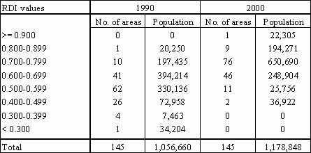
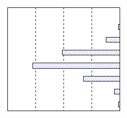
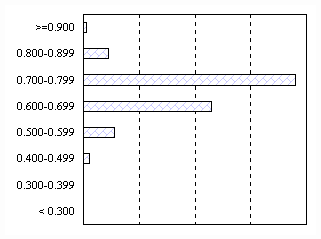
less) during period 1990 – 2000. Table A - Distribution of areas by RDI values, 1990
and 2000 In 2000, 10 out of the 145 areas scored RDI values of
0.8000 or higher compared to only 1 in 1990; 76 scored between 0.7000 and
0.7999 in 2000 compared to 10 in 1990 while 46 scored between 0.6000 and
0.6999 in 2000 compared to 41 in 1990. Figure 1: Distribution of areas by RDI values, 1990-2000 The number of areas scoring RDIs between 0.5000 and
0.5999 decreased drastically to only 11 in 2000 from 62 in 1990. Only two
areas scored less than 0.5000 in 2000 compared to 31 in 1990. These two areas are Le Morne VCA and Island of
Rodrigues which scored RDIs of 0.4264 and 0.4779 respectively; together,
they accounted for about 3% of the total population (37,000) in 2000.
Comparatively, the thirty-one areas scoring less than 0.5000 in 1990
accounted for about 11% of the total population (115,000).
Central Statistics
Office |